Mangroves on the mend: a global trend takes shape
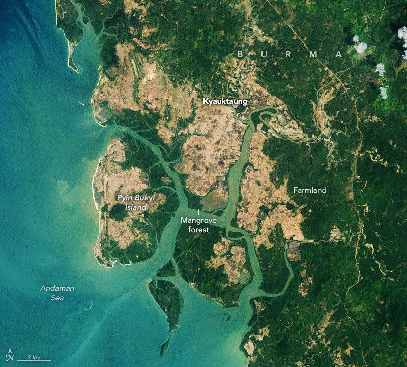
For much of the late twentieth century, mangrove forests were counted among the world's most rapidly disappearing ecosystems. Coastal clearance for agriculture, shrimp farming expansion, and urban encroachment stripped vast stretches of these salt-tolerant forests from tropical and subtropical shorelines across the globe. The trajectory seemed relentless. Now, satellite data analyzed by NASA points to a meaningful reversal: taken as a whole, the world's mangrove cover is growing again.
The recovery is uneven. Measurable gains have been documented across parts of Southeast Asia, West Africa, and Central America, driven by a combination of strengthened legal protections and natural regeneration in areas where human pressure has eased. Other regions continue to lose ground. What makes this trend legible at all is the precision of satellite-based land cover mapping, which can track subtle changes in coastal vegetation across vast areas and over time — something ground surveys alone could never achieve at this scale.
The ecological stakes extend well beyond biodiversity metrics. Mangrove systems act as buffers against coastal erosion, provide nursery habitat for a wide range of marine species, and sequester carbon at rates that rank among the highest recorded for any terrestrial ecosystem. Even a partial recovery carries significant environmental weight, and the data suggest the trend is real rather than a statistical artifact.
Heavy rains push Navajo Reservoir to rapid rise
Half a world away in physical terms but equally striking in its satellite signature, the U.S. Southwest experienced a sharp hydrological event in early November 2026. Successive rounds of heavy rainfall swept through the region, swelling river channels and sending far above-average volumes of water into Navajo Reservoir — the second-largest water storage body in the state of New Mexico.
Imagery captured by NASA instruments documented the change in clear terms: the reservoir's surface area expanded noticeably within days as inflowing rivers, fed primarily by the San Juan River basin, delivered runoff well in excess of seasonal norms. The speed of the rise was itself notable, reflecting both the intensity of the precipitation and the saturated or hardened soil conditions that limited absorption.
The event lands against a complicated backdrop. The American Southwest has endured years of structural drought that pushed reservoir levels to historic lows across the region. A rapid recharge event offers short-term relief to water managers and the communities who depend on these supplies, but it does not erase the cumulative deficit built up across multiple dry years. Extreme precipitation events also carry their own risks: flash flooding, erosion, and infrastructure stress that can accompany water arriving faster than systems are designed to handle.
Earth observation as an operational necessity
Separated by geography, theme, and scale, these two stories share a common thread: neither would be fully visible without space-based monitoring. NASA's Earth science missions provide the temporal continuity and spatial coverage needed to detect slow-moving ecological recoveries and fast-moving hydrological events alike — a capability no ground-based observation network can replicate on its own.
The data flowing from these missions informs researchers, but it also shapes decisions made by water authorities, environmental agencies, and governments managing landscapes under increasing climate pressure. As the pace of environmental change accelerates, reading the Earth from orbit has shifted from scientific privilege to operational requirement.